|
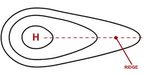
Earth's atmosphere exerts a pressure at the surface, where areas of high and low pressure are evident. These are caused by ascending and descending air masses; as air warms, it ascends leading to low pressure at the surface, whilst as air cools, it descends resulting in high pressure at the surface. The pressure differences result in the movement of air from high pressure regions to low pressure regions and this is what brings about winds.
|

|

|

A front is a boundary between two different types of air masses, for example a warm air mass from the tropics and a cold air mass from polar regions. A front can represent large temperature variations as the two air masses come together.
Warm Front - this is where warm air is advancing and stronger and the warm front is the leading edge of a warm air mass. As warm air is less dense than cold air, it rises above cold air and replaces cooler air at the surface (pressure falls). This can bring drizzly weather, as the warm air cools, water vapour condenses to form clouds which can be seen approaching. Cloudy weather tends to follow the warm front. |
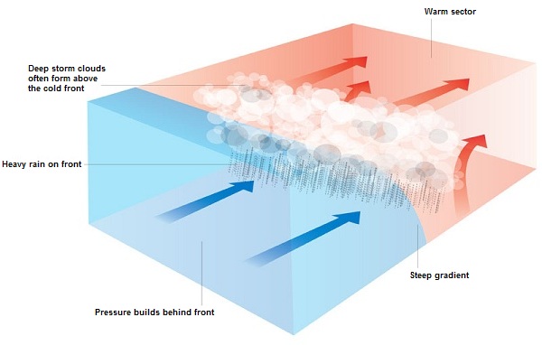
Cold Front - this is where cold air is stronger and advancing and the cold front is the leading edge of a cold air mass. The colder air pushes beneath the warmer air (as it is more dense) and replaces warm air at the surface. A cold front brings deep cloud layers as the warm air is forced to rise and cool, which produces rain and thunderstorms. However, following this there is often a dramatic clearance and clear, sunny weather. 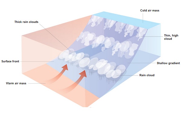
|

Occluded Front - an occlusion occurs where a cold front catches up with a warm front and the warm air is completely lifted from the surface. This sometimes occurs as cold fronts tend to move faster than warm fronts.
More information
Take a look these following links for further explanations and useful diagrams/animations:
Take a look these following links for further explanations and useful diagrams/animations:
